
Monze Education Fund
and Guide to Monze

|
|
Monze Education Fundand Guide to Monze |
|
|
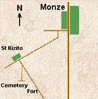
Fort Monze - Location and directions
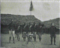
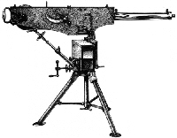
Cemetery S16° 22' 48.1" E27° 26' 25.3 You need a 4x4 although the road is impassable once the rains set in. Take the road due South out of Monze (in direction of Livingstone). A few hundred yards out of the 'main drag' of Monze, on the right hand side you should see a small sign to Fort Monze, take the road to the right. This takes you along a dirt road past a few shops. On the left you should see a commercial enterprise called '3rd World', take the left hand road and follow it in the direction of St. Kizito (and St. Mary's). After a few tens of minutes before you will find the mission of St. Kizito on the right. Look out for another sign to Fort Monze on the left. Follow this until you find a fork in the 'road' - take the right hand one. This becomes an even rougher, ungraded track. You need to follow this using your judgment. After a few kilometres (not too many, but very slow going) you will think the track has come to an end (NB At this point you are on a small plateau and if you look into your 7 o'clock position you should be able to see the Monze Silos in the distance through the bush trees). Looking straight ahead look hard for a badly rusted sign post. The site of the fort is 200 or so metres off to the left, the cemetery to the right another 400 or so metres. A track can be followed either way but it is likely to be heavily overgrown. Fort Monze todayThe site of Fort Monze is classified as a National Monument of Zambia. Up until the late 1950's the site of Fort Monze had been faithfully maintained by Hacheko Munamumba, an aging man of the Tonga peoples (the dominant tribe of this region). Because of its obscure location Fort Monze is unlikely to have been visited except by Munamumba and a few of his fellow villagers. For a small stipend Munamumba kept the site in pristine condition. In 1950 John Maybank, a Police Officer based in the town of Monze, brought it to the attention of the administration. Henceforth it received a steady trickle of visitors but this declined in recent years. Sadly, without the attention of Munamumba any longer, the site of the Fort is now largely overgrown and forlorn although plans are in hand to renovate the site of the fort and its small cemetery. Fort DescriptionThe remains of the Fort are still clearly defined in what was a compound 50-60 yards square bounded with quite high, sloping, grass-covered, earthen ramparts. Typical of forts in this style, the ramparts would have had locally sourced rough cut timber poles (braced and cross braced) lining the inner wall and earth excavated to form a ditch (5 feet wide and 3 feet deep) would have been stacked as a slope against the timber wall 5 feet in height above the ground surface, leaving a single entrance. Some forts of the period used sandbags to line the top. Stones or timber may have been laid at the foot of the slope to reduce erosion of soil into the ditch. It is likely that there was a platform in each of the corners on which the Maxim gun could be mounted when necessary. The ditch sometimes would fill with water although at Monze we are not sure if the soil would retain water for long. Nevertheless, the disadvantage of stagnant water forming a breeding ground for mosquitoes was known at the time and ditches which retained water were often drained. Within the enclosure a raised timber walkway, a couple of feet wide, would provide a platform to defend the stronghold. The police at Fort Monze were on good terms with Chief Monze and the Fort's function was probably limited as a secure enclosure with a prison hut and in all likelihood the armory for the Maxim gun, ammunition and rifles. In this space were found the foundations of several buildings - partly visible - and some old cooking stoves which were rusting away (a 1950's report by John Maybank). It is likely that the buildings within the ramparts did not accommodate personnel on a regular basis. Buildings erected for the police are believed to have been located outside of the stronghold, along with a parade ground, a krall for livestock and stables for the few horses. We know that the police erected a simple wooden fence around the whole area. A cultivated field was also used for crops. Buildings included: Equipment and stock included: |
|